In recent years, with the advancement of research on control algorithms, intelligent robots such as drones and unmanned vehicles have developed rapidly in various fields. When researchers carry out studies on intelligent robots, they usually need to complete simulation and debugging experiments in indoor environments. In these experiments, it is very important to accurately determine the positioning of each intelligent agent as well as their relative positions to other agents.
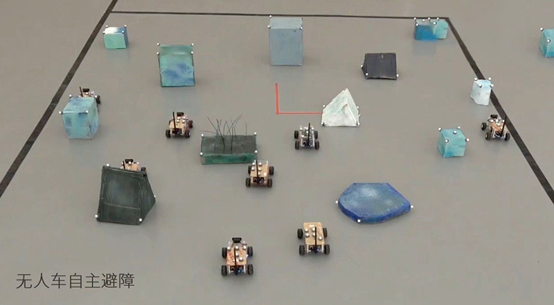
The current positioning algorithms can be broadly categorized into three types from a theoretical standpoint.
① Proximity method: This method utilizes the limited range of signal effects to determine if a test point is near a reference point, providing only a rough estimate of location.
② Scene analysis method: Measure the strength of the received signal and compare it with the signal strength at that location in the database to carry out the measurement.
③ Geometric feature method: An algorithm that uses geometric principles for positioning, which is specifically divided into trilateration, triangulation, and hyperbolic positioning methods.

Derived from the position algorithms introduced above, a variety of indoor positioning technologies have emerged. Currently, most positioning technologies require auxiliary nodes for positioning. They calculate the position of the node to be measured relative to the auxiliary nodes using different ranging methods, then compare it with previously collected data in a database to determine the current location.
The main process for indoor positioning involves setting up auxiliary nodes at fixed positions within the indoor environment. The locations of these nodes are known, with some storing location information directly within the nodes, such as RFID tags, while others store the information in a computer terminal's database, such as infrared or ultrasonic points.
Then, by measuring the distance from the node to be tested to the auxiliary node, the relative position is determined. Distance measurement typically requires a pair of transmitting and receiving devices, which can generally be divided into two types based on the location of the transmitter and receiver: one where the transmitter is at the test node and the receiver is at the auxiliary node, such as with infrared, ultrasound, and Radio Frequency Identification (RFID); and another where the transmitter is at the auxiliary node and the receiver is at the test node, such as with WiFi, Ultra-Wideband (UWB), and ZigBee.
Next, we will introduce the principles, advantages, and disadvantages of eight types of indoor positioning technologies.
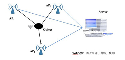
① Wi-Fi positioning technology uses scene analysis for localization with an accuracy ranging from 2 to 50 meters. Its advantages include easy installation and relatively high overall accuracy, but it suffers from the drawbacks of needing a large amount of fingerprint information and being susceptible to interference from other signals.
② Radio Frequency Identification (RFID) technology for video recognition locates objects using proximity information, with an accuracy range of 5 cm to 5 m. The advantages of this method include high accuracy, low cost, and small tag size, while the disadvantages are short positioning distance and difficulty in integration.
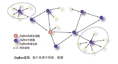
③ ZigBee positioning technology uses proximity-based positioning with an accuracy of 1-2 meters. Its advantages include low power consumption and cost; however, it suffers from low stability and is susceptible to environmental interference.
④ Infrared positioning technology also employs proximity-based positioning but with an accuracy of 5-10 meters. It offers relatively high accuracy but at the cost of higher production expenses, greater power consumption, and sensitivity to lighting conditions.
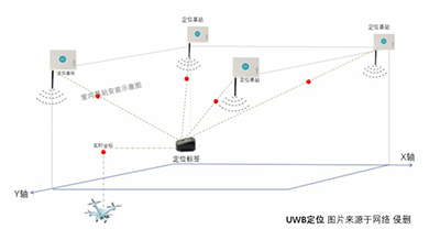
⑤ Ultra-wideband positioning (UWB) utilizes trilateration for localization, achieving an accuracy of 6-10cm. Its advantages include strong penetration, high precision, and low power consumption, while the drawback is the relatively high cost.
⑥ Ultrasonic positioning technology uses trilateration for positioning with an accuracy of 1-10 cm. Its advantages include high precision and simple structure; however, its disadvantages are multipath effects, environmental temperature sensitivity, and significant signal attenuation.
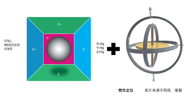
⑦ Inertial positioning is a method that uses data collected from inertial sensors, such as accelerometers and gyroscopes, to measure an object's motion speed, direction, and acceleration. The object's location is then obtained through integration location methods or dead reckoning. Its advantage is that it does not depend on the external environment, but its disadvantage is the cumulative error that increases with time while navigating. Therefore, it is generally used in conjunction with data from other sensors.
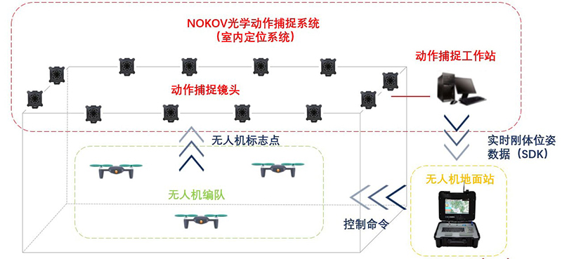
⑧ NOKOV indoor positioning technology is primarily used for real-time and accurate measurements to record the motion trajectories or poses of objects in true 3D space. Its optical motion capture system employs multiple high-speed cameras that monitor and track markers on the target from various angles. Based on computer vision principles, the system determines the position and motion trajectory of a point in space from the continuous image sequences captured by the high-speed cameras. The real-time rigid body pose data obtained are transmitted via SDK to the ground station of unmanned aerial vehicles (UAVs), which then outputs control commands to further control the movement of the UAVs. Considering different practical scenarios, the motion capture workstation can also send the real-time rigid body pose data directly to the UAV's control chip via SDK, allowing the UAV to perform data computations and achieve autonomous cooperative control.
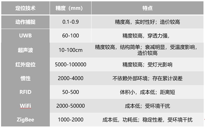
A comparison reveals that among all indoor positioning technologies, motion capture technology ranks first in accuracy, achieving sub-millimeter level measurement precision. The NOKOV motion capture system can obtain information about the position, orientation, as well as velocity and acceleration of the target object. It has the advantages of high technical maturity, high precision, and high sampling frequency, making it suitable for research requiring high-precision positioning.
For autonomous drones using onboard sensors like lidar, stereo cameras, depth cameras, and optical flow sensors for positioning and obstacle avoidance, the NOKOV motion capture system's data does not participate in flight control but provides high-precision reference position information for analysis.

For example, in the autonomous drone swarm construction system developed by the College of Architecture and Urban Planning at Tongji University, the NOKOV motion capture system was used. The construction system is composed of two parts: spatial posture feedback from drones and trajectory planning control from the ground station. The system's positioning requirements are divided into two parts: posture control and global positioning control. Although the NOKOV motion capture system can solve for the posture of rigid bodies indoors and offers better accuracy than onboard inertial measurement units, the system's built-in inertial measurement units are sufficient to support the rigid body's posture estimation. Therefore, in the posture control part, the commonly used solution in drone control is adopted, which integrates the drone's onboard attitude sensors, magnetometers, barometers, and airspeed sensors to process the drone's real-time local posture information. The system's global positioning control uses the NOKOV motion capture system based on optical infrared cameras to replace the commonly used outdoor GPS positioning system to track the real-time position of drones, meeting the operational requirements of stable hovering indoors and sending the drone coordinate information back to the ground station computer's visualization interface.

This autonomous construction real-time control system and visualization interface platform based on the NOKOV motion capture system have verified the capability of drones for building discrete structures. It also proposes an overall structural form and discrete unit shape for drone masonry based on the principles of spatial tessellation. This series of achievements provides further research ideas and methods for autonomous construction by aerial swarm intelligences.