Efficient navigation algorithms are the key to autonomous flight of quadcopters in complex environments. A computer system’s representation of the environment acts as the bridge between the perception modules of an aircraft and the route planning module and has a huge impact on the quality of the aircraft’s calculated route. Various algorithms have been proposed to construct navigation maps, each corresponding to different route-planning methods.
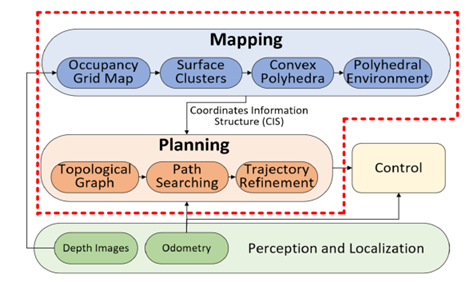
To improve the autonomous navigation capabilities of quadcopters, a research team at the Harbin Institute of Technology proposed a new map-based planning framework (shown in Figure 1). In the mapping module, polyhedral structures are used to represent observed obstacles and other environmental information is extracted from an occupancy grid map to support movement planning. In the planning module, a local topology map efficiently covering the surrounding area is generated, guiding the search for the best path using segmentation motion primitives. The safest and smoothest route is then obtained using a polynomial-based optimization algorithm.

Figure 1: Overview of the map-based planning framework.
This map-based planning framework is able to generate a polyhedral representation of the quadcopter’s environment online, provide comprehensive information on potential obstacles, and use the topology planner and a segmented search acceleration strategy to generate safe and smooth routes with sufficient clearance from obstacles.
Extensive simulations and experiments verify the effectiveness of this new map-based planning framework. A real in-flight experiment was conducted indoors, using the NOKOV motion capture system as a method to collect high-precision positioning information during the flight of the quadcopter.

Figure 2: Experimental flight environment of quadcopter aircraft.

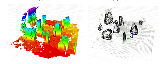
Figure 3: Generated grid map and polyhedral environment of the quadcopter’s surroundings.
Experimental results demonstrate that this new map-based planning framework outperforms certain baselines in both computational efficiency and route quality. The robustness and effectiveness of the framework have been verified in actual flight.
Bibliography:
Junjie Gao, Fenghua He, Wei Zhang, and Yu Yao. (2023). Obstacle-Aware Topological Planning over Polyhedral Representation for Quadrotors. In International Conference on Robotics and Automation (ICRA).