Research background
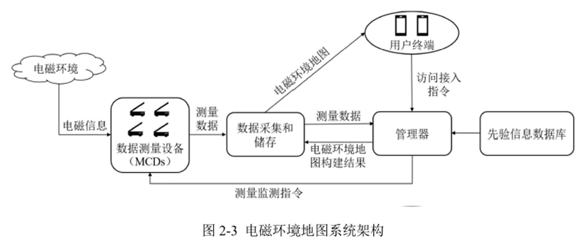
Electromagnetic Environment Mapping (EEM) is a quantitative description of the electromagnetic environment through multiple variables such as time, frequency, space, and field strength. Constructing an electromagnetic environment map allows one to create a visual display of the electromagnetic energy distribution of an area, which may aid in the monitoring and prevention of electromagnetic pollution. In the military, electromagnetic environment mapping directly supports electromagnetic spectrum warfare, causing the construction of electromagnetic environment maps to become a topic of extensive attention and research.

The first step in electromagnetic environment mapping is to collect electromagnetic information over a certain area. Due to the difficulties of maneuvering physical terrain, Unmanned Aerial Vehicles (UAVs), which are both high-utility and cost effective, have become the best choice. Moreover, the speed of task execution, success rate of task completion, and accuracy of data collected by a group of UAVs are much higher than that of a single UAV.
Study overview
The digital pheromone-based wolf pack algorithm proposed by the research team of the Department of Instrument Science and Technology at the University of Electronic Science and Technology of China enables a UAV swarm to preemptively search for dangerous flying areas and optimize path planning. The team designed an attention-based partial convolutional neural network to generate a high-precision electromagnetic environment map.
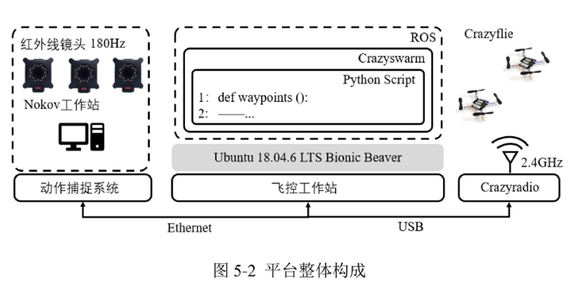
To test the efficacy of this algorithm, a hardware-in-the-loop simulation was conducted using a quadrotor UAV equipped with a measurement chip.

The hardware used included a NOKOV optical 3D motion capture system equipped with 24 Mars 4H motion capture cameras. With a resolution of 4 million pixels, a 180Hz refresh rate, and only 5.2ms of latency, these cameras were able to provide a 52° field of view with submillimeter level accuracy.
Additionally, the NOKOV Seeker 1.6 motion capture software supports a variety of useful features, including system calibration and correction, data collection and exportation, a real-time SDK, and the ability to import data into MATLAB, C++, Linux, Simulink, and other platforms in real time. This software also incorporates both point-cloud matching and rigid body matching to distinguish targets.

Bibliography:
Li Tong. Research on electromagnetic environment map construction method based on UAV swarm [D]. Chengdu University of Electronic Science and Technology of China, 2022.